Marble: Difference between revisions
Pipesmoker (talk | contribs) mNo edit summary |
(Marked this version for translation) |
||
| (19 intermediate revisions by 7 users not shown) | |||
| Line 1: | Line 1: | ||
{{ | <languages /> | ||
<translate> | |||
<!--T:1--> | |||
{{EduBreadCrumbs}} | |||
<!--T:2--> | |||
| [[Image:marble.png| | {| | ||
| '''Marble is powerful virtual globe and world map.''' | | [[Image:marble.png|64px]] | ||
| '''Marble is a powerful virtual globe and world map.'''<br /> | |||
It is part of the [http://edu.kde.org KDE Education Project]. | |||
|} | |} | ||
<!--T:3--> | |||
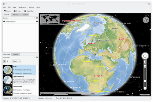
[[Image:marble_welcome.png|500px|center]] | |||
For a short introduction into Marble you might want to have a look at the | <!--T:4--> | ||
For a short introduction into '''Marble''' you might want to have a look at the | |||
[http://developer.kde.org/~tackat/marble-akademy2009.pdf slides of our presentation about Marble] at [http://www.grancanariadesktopsummit.org Akademy / GCDS 2009]. | [http://developer.kde.org/~tackat/marble-akademy2009.pdf slides of our presentation about Marble] at [http://www.grancanariadesktopsummit.org Akademy / GCDS 2009]. | ||
<!--T:5--> | |||
There's also a [http://www.youtube.com/watch?v=iukEWGoDNho YouTube-video of the first 10 minutes] available. The full video can be downloaded [http://www.geeksoc.org/gcds/Torsten%20Rahn,%20Marble.ogv here]. | There's also a [http://www.youtube.com/watch?v=iukEWGoDNho YouTube-video of the first 10 minutes] available. The full video can be downloaded [http://www.geeksoc.org/gcds/Torsten%20Rahn,%20Marble.ogv here]. | ||
==Features== | ==Features== <!--T:6--> | ||
<!--T:7--> | |||
* You can pan and zoom around and you can look up places and roads | |||
* A mouse click on a place label will provide the respective Wikipedia article | |||
* You can measure distances between locations | |||
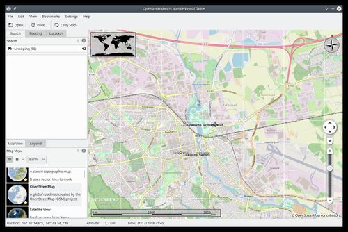
* It offers different thematic maps: A classroom-style topographic map, a satellite view, street map, earth at night and temperature and precipitation maps. All maps include a custom map key, so it can also be used as an educational tool for use in class-rooms | |||
* For educational purposes you can also change date and time and watch how the starry sky and the twilight zone on the map change | |||
* Supports multiple projections: Choose between a Flat Map ("Plate carré"), Mercator or the Globe | |||
* Promotes the usage of free maps | |||
==Screenshots== <!--T:8--> | |||
<!--T:9--> | |||
[[Image:Marble_streetmap.jpg|thumb|500px|center|''Streetmap of Linköping in Sweden'']] | |||
== Tutorials == <!--T:15--> | |||
<!--T:16--> | |||
* [[Special:myLanguage/Marble/MapThemes|Map Theme Configuration]] | |||
* [[Special:myLanguage/Marble/Bookmarks|Using Bookmarks]] | |||
== | === Maemo (Marble for Nokia N900) === <!--T:17--> | ||
<!--T:18--> | |||
* [[Special:myLanguage/Marble/Maemo/Installation|Installing '''Marble''' on a Nokia N900]] (obsolete) | |||
* [[Special:myLanguage/Marble/Maemo/OfflineRouting|Setting up Offline Routing on a Nokia N900]] (obsolete) | |||
* [[Special:myLanguage/Marble/Maemo/GuidanceMode|Route Planning and Guidance Mode on a Nokia N900]] (obsolete) | |||
* [[Special:myLanguage/Marble/Tracking|GPS Tracking]] (obsolete) | |||
* [[Special:myLanguage/Marble/Bookmarks#Bookmarks_on_the_N900|Using Bookmarks]] (obsolete) | |||
* [[Special:myLanguage/Marble/Search|Searching Places]] (obsolete) | |||
== | == More Information == <!--T:12--> | ||
* [http://docs.kde.org/development/en/kdeedu/marble/index.html | <!--T:13--> | ||
* [http://marble.kde.org/ Marble website] | |||
* [http://docs.kde.org/development/en/kdeedu/marble/index.html Marble Handbook] | |||
* [https://en.wikipedia.org/wiki/Marble_(software) Wikipedia] | |||
<!--T:14--> | |||
[[Category:Education]] | [[Category:Education]] | ||
[[Category:Science]] | |||
[[Category:Mobile]] | |||
</translate> | |||
Latest revision as of 14:30, 20 April 2019
Home » Applications » Education » Marble

|
Marble is a powerful virtual globe and world map. It is part of the KDE Education Project. |

For a short introduction into Marble you might want to have a look at the
slides of our presentation about Marble at Akademy / GCDS 2009.
There's also a YouTube-video of the first 10 minutes available. The full video can be downloaded here.
Features
- You can pan and zoom around and you can look up places and roads
- A mouse click on a place label will provide the respective Wikipedia article
- You can measure distances between locations
- It offers different thematic maps: A classroom-style topographic map, a satellite view, street map, earth at night and temperature and precipitation maps. All maps include a custom map key, so it can also be used as an educational tool for use in class-rooms
- For educational purposes you can also change date and time and watch how the starry sky and the twilight zone on the map change
- Supports multiple projections: Choose between a Flat Map ("Plate carré"), Mercator or the Globe
- Promotes the usage of free maps
Screenshots

Tutorials
Maemo (Marble for Nokia N900)
- Installing Marble on a Nokia N900 (obsolete)
- Setting up Offline Routing on a Nokia N900 (obsolete)
- Route Planning and Guidance Mode on a Nokia N900 (obsolete)
- GPS Tracking (obsolete)
- Using Bookmarks (obsolete)
- Searching Places (obsolete)
